Tuesday, December 27, 2011

Bay of Islands

We snuck away to one of the water recreation capitals of New Zealand, the Bay of Islands, for a two day trip. It’s north of Auckland and about a three hour drive. As you can tell by the name, it’s a ‘bay’ and it’s full ‘islands’. The Kiwis are very good in their descriptions.
It’s a popular destination during the summer for all sorts of water activities…..fishing, boating, jet skiing, sailing, and swimming with dolphins. We got on the water as well and went on a sailing trip to one of the uninhabited islands.
We sailed on the R. Tucker Thompson, which is a classic looking schooner. The namesake started construction in the 1970’s, however died before the boat was complete. His family finished the boat as a tribute and the sailing crew now operates the boat as a non-profit with proceeds going towards a youth leadership program where the crew brings along teenagers on week long voyages. They allowed you to climb up the mast, or onto the bow of the ship. I gave it a shot:

The island had a short hike with a fantastic view of the surrounding area:

We also visited the Waitangi Treaty Grounds, an important historical site for New Zealand. This is where in 1940 the local Maori tribes and the British signed a treaty putting the sovereignty of New Zealand under the British Empire. The treaty is viewed as having made New Zealand a British colony and is considered the founding document of New Zealand. However there continues to be disagreement over Maori translation of the document regarding land ownership.
A couple of photos from the traditional Maori wharenui (meeting place) at the treaty grounds:


We also fit in a hike across some mangroves to a waterfall. Found a bunch of these birds nesting in the trees above the track. I’m going to test the Olmsteads (college friends who are bird enthusiasts) to see if they can identify the bird.

Sunday, December 25, 2011

Christmas in Shorts

I’m in shorts and sandals (known as ‘jandals’ in New Zealand) for Christmas. And Dana has a sunburn. It just doesn’t  feel quite right. It is the one day each year where having a little snow is a good thing. Most Christmas songs don’t make sense in New Zealand, at least any song involving a snow man or sleigh rides. However Kiwis have their own traditions they follow around the holiday season. Here are a couple of differences:
-          Many workers have off until mid January. Our office is closed from Dec 23rd to Jan 15th. And there are many that just take all of January off. Unfortunately those ER doctors are still needed, so no long break for Dana.
-          The Queen gives a Christmas speech to all the commonwealth countries. It’s on TV early evening in New Zealand.
-          The sky tower is lit up red and green:


-          Many families flock to the beach for their Christmas dinner “picnics”.
-          The local pohutukawa tree is known as the ‘New Zealand Christmas Tree’. It blooms with red blossoms in December.

-          They call the holiday season ‘the silly season’. I’m assuming that’s because some of them are attending far too many holiday parties. Have noticed some hungover looks at the office and comments about liver health.
-          One street in our neighborhood is famous throughout the city for having Christmas lights. The adjacent streets are all backed up with cars trying to drive down it, and on Christmas the sidewalks were full with admirers. Happy to report that there was only one house with the American favorite, the blow up lawn decoration. While none of the houses go to the super extreme that you might see on you tube videos complete with sound track, overall the atmosphere was pretty impressive. 
Anybody bothering to read the blog today, want to wish you a Merry Christmas. For our families, Christmas isn’t the same without you around. We’re both missing you today.

Tuesday, December 20, 2011

Glacier Country

Visiting Glacier Country was supposed to be the highlight of our trip to the South Island, and it certainly didn’t disappoint. There are 2,500 glaciers in New Zealand (doesn’t that sound like a lot?), but only two that are accessible to visit….and they happen to be almost right next to each other. Nestled into the Southern Alps are the Franz Josef Glacier and Fox Glacier. We had read that the Fox Glacier is a better experience on the Glacier, so our aim was to take a guided helicopter tour which drops you off on the glacier for a two hour hike. As mentioned in the last post, the weather wasn’t cooperating well, so the odds seemed slim that we could get a helicopter ride. The first two helicopter tours were cancelled on the day we were visiting. While waiting for the flight, we walked up to the face of the Fox Glacier. At the foot of the Glacier is a rainforest, complete with moss growing on trees, plenty of ferns and streams with crystal clear mountain snow runoff. Here are a few photos of the rainforest and Fox Glacier:


After the second flight of the day was canceled, we drove to the Franz Josef Glaicer. During our walk to the face of the Glacier, the weather gods finally decided to smile upon us and the sun peaked through. The hike to the Franz Josef Glacier was beautiful as it crossed through rainforest and then into a cavernous valley that leads up to the massive block of ice. Couple pictures of the Franz Josef and the surrounding valley:
If you look at the bottom of this picture, you’ll see that there is a substantial amount of water flowing out of the bottom of the glacier and it’s gray in color. All of the glacier runoff has this milky gray look to it due to the combination of glacier particles along with the melting ice.
With our hopes lifted by the sun, we returned to the Fox Glacier (they are about 20 km apart) and the weather had improved enough that the guiding company was going to get the helicopter up in the air. Dana and I have taken two helicopter rides together before, one at the Grand Canyon and one at Volcano National Park in Hawaii. Both were amazing experiences that let you get a whole new appreciation for the dramatic scenery. This helicopter ride was better than both of them. Maybe it’s due to restrictions in the US, but those helicopter rides were tame compared to the aggressive dives that our Kiwi pilot took us on. At times it certainly felt like we were flying more vertical than horizontal and it provided an amazing sweeping view of the entire glacier. All the G forces turned out to be a little much for one Australian who was left feeling light headed after the ride. Dana got a front seat view with the pilot and took the opportunity to get some great photos:


This is Victoria Falls that is mountain runoff that plummets right into the glacier in these last three. The helicopter got us a great view and the drop off below what you can see here is hundreds of feet.
The helicopter left us and we hiked around on the glacier with our guides from Nepal and Iceland. The huge scope of the glacier and the surrounding mountains makes you feel small and insignificant. There were some amazing blue colors that were created from the ice. We drank glacier water, which apparently isn’t as ‘nutritious’ as spring water because it lacks some minerals…..however it tasted great. We spent around a hour and a half exploring the glacier:


We still had about an hour to go on the exploration, however with dark clouds forming in the valley, the helicopter team radioed that the conditions were deteriorating and we should head back early. At this point the guides rounded the group up and led us back to the makeshift helicopter landing pad (which was on ice, and just had some rocks to outline the flat area). We waited at the landing pad listening to the dispatchers below comment on how dark the clouds were and how the helicopters were trying to go through, but didn’t have enough visibility. At first there was some good natured laughing among the group and guides as to how we would cope up on the glacier for the night. After about a half hour or so, the possibility of us spending the night on the glacier seemed to get more real as it started to rain and the clouds were a dark dark grey. There was precedence for this as two guided groups had previously spent the night on the glacier. We didn’t become the third. Thankfully they brought in a second helicopter pilot who bravely found a sliver of visibility and made it to pick us up. Here is what the mountains looked like with helicopter coming back.

Amazing trip and lucky to have that sliver of good weather to get in a full glacier experience.

The Wet Coast

It is technically summer in New Zealand, but it continues to feel more like springtime. What I mean by that is that it’s still raining…a lot. Our trip to the South Island was no exception. It rained about 75% of our trip. The scenic drive in the Southern Alps through Arthur’s Pass was impressive, but when clouds are covering the mountains and the visibility isn’t great….you lose a little bit. However we were able to sneak in a few pictures of the landscape when it wasn’t pouring:


We stayed in a small town on the West Coast, Greymouth. A pretty non descript town. The one thing they did have going for it was that it’s the home on Monteith’s Brewery. Just happens to be the best brewer in New Zealand (in my opinion). We went for a tour and tasting. They even put me to work:
We did run into one of the local celebrities, the Kea. A type of parrot that lives in the mountains, this bird is known for its intelligence and curiosity. Three were waiting in the rain outside the two restaurants in the small town of Arthur’s Pass as we stopped for lunch. They were not in the least bit afraid of human interaction or cars. Apparently they are known as the “Clowns of the Mountains” for how interactive they are with humans. The locals warn of not feeding them as they can become dependent on handouts which danger their natural survival skills.

Sunday, December 18, 2011

Christchurch

Earthquakes do serious damage. You can’t really comprehend the immense damage an earthquake can produce until you’ve seen the impact close up. We visited Christchurch on the South Island this past week, and the city looks like an abandoned war zone. Christchurch has suffered through three large earthquakes recently in September 2010 (7.1 magnitude), February 2011 (6.3 magnitude), and June 2011 (6.3 magnitude). The February 2011 quake was the worse as it was centered only a few kilometers from the center of town. 181 people died making it the second most deadly natural disaster in New Zealand, and is estimated to have done $20-$30 Billion (NZ dollars) of damage making it the third costliest earthquake in world history. We drove through the streets almost a year later and still saw faces of buildings that were torn down, rubble in the streets, and a once busy downtown was abandoned except for construction workers working on repairs…..


Christchurch is the biggest city in the South Island and maintains a more laid back feel than Auckland and Wellington. The landscape is completely different as well as it’s completely flat, which makes you feel like you’re not in New Zealand at all. We didn’t spend much time in Christchurch as our ambitions for the trip were to visit the Southern Alps and the Glaciers, however our short stay did leave a big impression on us.
More coming in the next couple of days on the rest of our trip. Check back.

Saturday, December 10, 2011

The Capital City

New Zealand only has two large cities. We live in one of them, and visited the other, Wellington, this past week. Located at the bottom of the North Island, Wellington is the capital and is often compared to San Francisco due to the hilly landscape and similar weather. As one of two real cities in New Zealand, it needs a comparison to Auckland. Pluses: older buildings that give the city more character, fantastic food, all of the city’s cultural highlights are within walking distance. Minuses: often has overcast/rainy weather (its the windiest city in the southern hemisphere!) and the infrastructure is older (narrow streets).
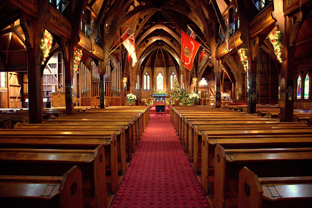
We had two days and took in the Wellington highlights: Te Papa, Wellington’s six level museum on all things New Zealand, a tour of the Government buildings (nicknamed the Beehive), a visit to a replica Stonehenge, the nearby Martinborough vineyards where Pinot Noir is the local specialty, and a drive down the coast to Cape Palliser.
Downtown Wellington.
Old St. Paul’s Church. All geared up for Christmas.
 Downtown. Interesting bit about Wellington….it’s on a fault line. It had a 5.1 earthquake a few days before we visited, and heard on the radio there was a 4.2 earthquake while we were there (although we either didn’t notice or were in the car). The city was put there because of the potential for deep water port even with the knowledge of the potential earthquake issues.

The Beehive
A seal colony lounging on the rocks near Cape Palliser. I disturbed them trying to get a photo and received plenty of hissing for interrupting their naps.
Cap Palliser lighthouse. Steep 250 steps to the reach it.  
I can’t completely explain this picture, but I can say this tractor and boat combo were one among many on the beach in a small coastal town. All I know is the owner of the tractor is riding in style!
Small beautiful country has small beautiful churches.

Sunday, December 4, 2011

Te Henga Walkway

It's hiking season in New Zealand. Last week marked the first day of summer and the rain has mostly slowed down. We've got a 4 day, 53 km hike coming up in February, so it's time to start getting the hiking legs ready. I took a great hike yesterday along Te Henga Walkway on Auckland's west coast, which is part of a 4 day hike called the Hillary Trail. I hope to tackle the full Hillary Trail (70 km) in pieces. Here are a few pictures of the coastal scenery: